-2%New
Garmin zūmo XT2 MT-S – Advanced Motorcycle GPS Navigator
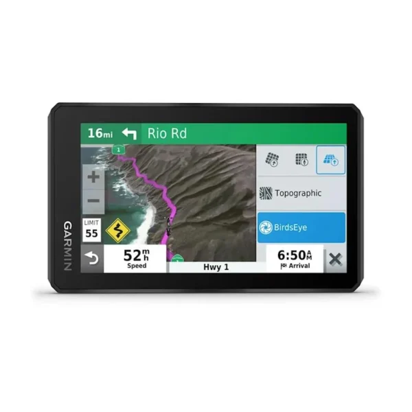
The Garmin zūmo XT2 MT-S is a next-generation motorcycle GPS navigator built for on-road touring and off-road adventure and is available at Mobihub Electronics Kenya. Designed to meet the rugged demands of motorcyclists, the XT2 expands on the original zūmo XT platform with a larger, brighter display, enhanced mapping, improved group ride features, and more robust navigation tools.
Display and Design
6-Inch Ultrabright Touchscreen
Offers a large, high-resolution (1280 x 720) display that is 15% larger than the original zūmo XT. The screen is glove-friendly, viewable in direct sunlight, and responsive to rain and varying light conditions.Rugged and Waterproof
Built to IPX7 standards with resistance to rain, vibration, dust, and UV exposure. Designed to withstand off-road conditions, long rides, and extreme environments.Portrait and Landscape Modes
Flexible orientation allows riders to mount and view the device vertically for long trail views or horizontally for broader route coverage.
Navigation and Mapping
Preloaded Maps
City Navigator® for detailed road navigation with turn-by-turn directions
TopoActive Europe or region-specific topographic maps for off-road routes
Global BirdsEye Satellite Imagery – high-resolution imagery downloadable directly to the device, with no subscription required
Garmin Adventurous Routing™
Customize routes to prioritize curves and hills, avoiding highways for more scenic, exciting rides.Track Recorder and GPX Compatibility
Record your route in real time and follow pre-planned GPX tracks shared by others or created in Garmin Explore™.Visual Ride Summaries
After completing a route, the XT2 provides a visual summary with elevation, speed, and ride data analytics.
Group Ride and Communication
Group Ride Mobile
Using the Garmin Tread® or Drive™ app, riders can share their real-time location with other riders, even without dedicated group ride hardware. Requires cellular coverage and compatible smartphones.Group Ride Radio Compatibility (optional accessory)
Riders can pair with Garmin’s Group Ride Radio accessory for device-to-device tracking and voice communication without cellular data.
Smart Features and Connectivity
Wi-Fi® Updates
Allows wireless map and software updates without a computer. The device notifies the user when updates are available.Bluetooth® Integration
Pair with a compatible smartphone and Bluetooth-enabled helmet or headset for:Hands-free calling
Smart notifications (texts, alerts, app messages)
Spoken turn-by-turn directions
Garmin Drive™ and Explore™ App Support
Sync routes, download maps and satellite imagery, manage saved tracks and waypoints, and plan off-road routes using these apps.
Motorcycle-Specific Tools
Rider Alerts
Warns of upcoming curves, animal crossings, school zones, railroad crossings, and speed changes to promote safe riding.Live Traffic and Weather
When connected to the Garmin Drive app, users receive real-time traffic conditions and weather updates directly on the XT2.Compatible with InReach® Devices
Can connect with Garmin inReach® satellite communicators for global two-way messaging, interactive SOS, and location tracking (sold separately, subscription required).
Power, Mounting, and Battery
Battery Life
Up to 6 hours of continuous use, or 3.5 hours at 100% screen brightness. For extended use, the device includes a hardwired motorcycle power cable for constant charging.Mounting Kit Included
Includes a rugged motorcycle mount, power cable, and RAM® mounting hardware for secure installation.
In the Box
Garmin zūmo XT2 device
Motorcycle mount and power cable
RAM® mounting hardware
USB cable
Quick start manual
Ideal For
Adventure and dual-sport riders
Long-distance touring motorcyclists
Off-road explorers who need satellite imagery and topographic data
Groups or clubs looking for real-time ride sharing
Riders who want navigation, route tracking, and smart features all in one rugged device
Summary
The Garmin zūmo XT2 MT-S is a rugged, feature-rich GPS navigator crafted for the modern motorcyclist. With a bright 6″ display, topographic and road navigation, group ride tools, wireless updates, and off-grid capabilities, it empowers riders to explore confidently on-road and off-road. Whether riding solo or with a group, the zūmo XT2 enhances every journey with intelligence, visibility, and adventure-ready performance.


