-4%


Waypoints & Tracks: Basic navigation tools for outdoor travel
Long Battery Life: Up to 168 hours in GPS mode
Multi-GNSS Support: Enhanced accuracy with multiple satellite systems
Geocaching Ready: Supports automatic updates and logging
Digital Compass: Accurate heading without movement
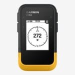
Sunlight-Readable Display: Clear in bright conditions
Rugged Build: Durable and weather-resistant
Wireless Sync: Connects with Garmin Explore app for planning and tracking
KSh 23,500.00 Original price was: KSh 23,500.00.KSh 22,500.00Current price is: KSh 22,500.00.
Payment Methods:

The Garmin eTrex SE is a purpose-built handheld GPS unit designed to deliver dependable navigation, exceptional battery life, and rugged durability—all at an accessible price and is available at Mobihub Electronics Kenya. It caters to outdoor enthusiasts, hikers, field workers, and geocachers who need a no-nonsense, highly portable GPS tool. While it lacks advanced mapping or touchscreen capabilities, it excels in simplicity, endurance, and usability in challenging environments.
The eTrex SE is equipped with a 2.2-inch monochrome display, using a high-contrast screen that remains clear and easy to read in all lighting conditions, including full sunlight. Unlike color screens or touch interfaces that consume more power, this screen is intentionally simple to extend battery life and improve outdoor visibility.
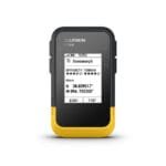
The device is fully button-operated, using tactile buttons on the sides and front for navigation through menus and map screens. This makes it ideal for use in extreme environments—gloved hands, rain, mud, or dust won’t interfere with operation. The interface is intentionally minimal and straightforward, making it accessible for beginners and efficient for seasoned users.
Designed for harsh outdoor conditions, the Garmin eTrex SE has a durable, shock-resistant body with a textured exterior for grip. The device is rated IPX7 water-resistant, meaning it can withstand splashes, rain, and even submersion in 1 meter of water for up to 30 minutes. It also holds up well against dust, dirt, and accidental drops, making it suitable for rugged fieldwork, camping, hunting, and trekking.
One of the standout features of the eTrex SE is its exceptional battery life. It runs on two standard AA batteries—either disposable alkaline or rechargeable NiMH cells—and can operate for up to 168 hours (7 days) of continuous GPS tracking in standard mode. This efficiency makes it an ideal tool for multi-day expeditions or situations where recharging isn’t possible.
The simplicity of the display and the efficient GPS chipset contribute to its ultra-long runtime, setting it apart from more power-hungry touchscreen GPS units or smartwatches.
The eTrex SE supports Multi-GNSS reception, which means it can simultaneously connect to multiple satellite constellations, including:
GPS (United States)
GLONASS (Russia)
Galileo (European Union)
QZSS (Japan)
BeiDou (China)
This multi-system capability significantly improves accuracy, speed of satellite acquisition, and reliability—especially in environments where signals are often blocked or distorted, such as dense forests, canyons, urban areas, or mountainous terrain.
The unit uses a high-sensitivity receiver to ensure consistent tracking even under tree cover or in adverse weather.
While it doesn’t have full topographic mapping, the eTrex SE includes a robust suite of essential navigation tools:
Waypoints: Store and name specific geographic locations to navigate back to.
Routes: Plan and save multi-point routes to follow across terrain.
Track Logging: Record breadcrumb trails of where you’ve been; these can be followed back using the “TrackBack” feature.
TrackBack Navigation: Allows the user to reverse a recorded track and navigate safely back to the starting point.
Digital Compass: Displays heading and directional data while the user is in motion (not a magnetic compass; movement is required).
These tools allow for safe off-grid exploration, making the unit suitable for backcountry hikes, scouting, orienteering, and basic surveying.
The eTrex SE supports paperless geocaching, allowing users to download GPX files with cache descriptions, logs, and hints. This means there’s no need to print out directions or manually enter coordinates—the caches can be viewed directly on the device. Geocaching features are integrated in a user-friendly way, making it accessible to beginners while still useful for serious geocachers.
The eTrex SE includes Bluetooth connectivity, which allows it to sync with the Garmin Explore app on a compatible smartphone. Through the app, users can:
Plan trips and routes in advance
Sync waypoints, tracks, and routes wirelessly
View real-time GPS position over maps on the phone
Upload trip data to the cloud for backup and sharing
Receive firmware updates wirelessly
Set up and manage geocaches
This added layer of wireless functionality gives users flexibility without requiring a complex or always-connected smart device. It also allows for seamless data transfer without cables.
The Garmin eTrex SE is ideal for users who need reliable GPS performance in a compact, ultra-durable form. Its use cases include:
Hiking and Backpacking: Basic but essential navigation tools for staying on route and returning to camp.
Field Work and Data Collection: Ideal for outdoor professionals who need to mark and record locations accurately.
Geocaching: Designed for recreational and hobby use, with full support for digital caching.
Disaster Preparedness and Emergency Use: Extremely useful in regions where mobile connectivity is unreliable or absent.
Travel and Expeditions: Lightweight, portable GPS option for remote travel and adventure.
The Garmin eTrex SE delivers essential GPS navigation in a rugged, long-lasting, and affordable package. It stands out for its:
Simple, button-based operation
Long battery life (up to 168 hours)
Multi-GNSS satellite reception
Basic navigation tools (waypoints, tracks, compass)
Bluetooth connectivity for Garmin Explore
Rugged, waterproof design
It’s an excellent choice for users who prioritize function over frills and need a reliable handheld GPS that just works—no touchscreen, no maps, no distractions.
Subscribe to get the latest posts sent to your email.
No account yet?
Create an Account


